• Holiday Sale on Classic Black and White Images of Route 66 Landmarks

    Click Image

  • Along Route 66

    Click to Buy Book

  • Route 66

    First 66 Book

  • April 2024
    M T W T F S S
    1234567
    891011121314
    15161718192021
    22232425262728
    2930  
  • Categories

Oklahoma: the state that most symbolizes the historic Mother Road

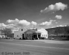
Leon and Ann Little’s Hinton Junction Cafe and Motel

Daio Hoffman asked on the Route 66 site on Linked-in if there is a place on Route 66 that most symbolizes the Mother Road.

There is: the State of Oklahoma. When the Joads and the Okies were fleeing west to California to escape the Dust Bowl, people like Ann and Leon Little migrated to Route 66, pumped gas, and served burgers to the people going west. This happened over and over in Oklahoma.

From Along Route 66:

“Ann and Leon Little made a good living on this stretch of highway west of El Reno. When they married in 1932, they bought an old gas station next to the Swinging Bridge on 66 at Bridgeport. In 1934 when the new bridge over the South Canadian was completed several miles south of Bridgeport, the Littles built a new station at the west end of the bridge at the intersection of U.S. 66 and U.S. 281. They called the place Hinton Junction. Six years later they expanded their business and built a third station, a cafe, and motel west of the junction. Little laid up walls of structural clay tile which he protected with stucco. He whitewashed the imposing two-story gas station and residence–razed before 1981–and the boxey cafe, but Oklahoma dust soon turned the buildings pink. The eight room motel was a long, low ranch-style bungalow set on the back of the property. When Leon was drafted in 1943, he leased the business to E.B. Enze who closed down Leon’s complex, and opened his own business in a new stucco building at the intersection of 66 and 281. When Leon returned from the war, he and Ann had to start over.”

Ann described serving a meal during the Dust Bowl. She set the meal on the table, and drew the corners of the table cloth over the meal to protect it from the dust. When Leon came in from building the new gas station, she carefully, folded the corners back to keep the dust from falling into the food.

Ann and Leon did so well after World War II, when Americans started traveling for fun, that they were able to send their kids to college and retire to a nice ranch house in Hinton, when I-40 opened and replaced 66 through Oklahoma.

Down the road from the Littles’ place was Bridgeport, actually new Bridgeport. From Along Route 66:

“Before 1934 Harvey Wornstaff ran a gas station at the east end of the Swinging Bridge at Bridgeport. When the Oklahoma Highway Department rerouted 66 across the new bridge,  the citizens of Bridgeport got in a dispute about the future of their town. Bridgeport had no future. The fight ended in a draw. Half the town moved to Hinton; the other half to new 66 where they established a roadside stringtown they named Bridgeport. It stretched for a mile along 66, all little gas stations, motels, cafes, food stands, and a dance hall. Dale Lee had a gas station and repair shop; Jack Hind a gas station and hamburger stand; Velma and Ray Yount a gas station and lunch room; Nancy Rose a grocery with pumps; Happy Jack the dance hall, and so on, all competing for the dollars that came down 66. Harvey Wornstaff had a gas station, restaurant, and motel. He named it after himself, and housed the restaurant, the gas station, and his living quarters in the low stucco building. To the east, he built little square cabins for overnight guests. What was left of old Bridgeport? A grocery, an old hotel converted to apartments, the post office, and the telephone office–that was it; the rest just disappeared as did new Bridgeport after the interstate replaced 66 in 1962.”

When you travel U.S. 66 in Oklahoma, don’t ignore all those broken down stucco buildings that date back to the 1930s. They are the real 66 and the people who lived  and worked in them made their livings from the people who migrated west during the Dust Bowl and thrived after World War II and during the 1950s.

Visit AlongRoute66.com is see more photographs of the old highway in Oklahoma.

The Ostermann Station in Peach Springs, Arizona has been placed on the National Register of Historic Places

Osterman’s Shell Station, 1932

Peach Springs

Oscar Ostermann's Gas Station in Peach Springs

The Hualapai Indians nominated the Peach Springs Shell Station for the National Register of Historic Places and were accepted in 2009. Recently, it was placed on the register. The Hualapai Indian tribe owns the station these days and plans to restore it and start pumping gas again. They received a great from the National Park Service to do so. However,  Oscar Ostermann built the gas station in 1932, not his brother John in 1927. At the same time Oscar built the new gas station, he built the Peach Springs Auto Court next door.

Beatrice Boyd, whose husband, Frank, worked for Oscar and who purchased the Peach Springs Auto Court from Oscar in 1938, told me the story:

From Along Route 66:

“Swedish sailor John Osterman wanted to captain his own ship. In 1914 he set sail around the world, as was required by the Swedish Merchant Marine, but on a German ship. His ship was interned at Santa Rosalia, Mexico on the Baja Peninsula at the beginning of World War I. He jumped ship, ferried across the Gulf of California, made his way to Nogales, crossed the border into Arizona, and followed the railroad north to Phoenix where he went to work in a dairy. He hated the work. When the dairy shipped its cows, and John north, to summer pastures near Flagstaff, he took off and hopped a train to San Francisco with the intention of going back to sea. The railroad cops threw him off at Peach Springs where the largest body of water was a dry wash.

“He stayed, worked on a ranch, became a citizen, and was drafted when the United States went to war. After World War I, he returned to Peach Springs, opened a small gas station, and quickly developed a reputation for honest work. He would tow a car day or night. He stocked Ford parts, particularly springs–six were delivered daily from Los Angeles for folks who busted theirs on the rough road. He persuaded his brother, Oscar, to join him, sold him the gas station in 1925, and moved to Kingman. A year later the highway department designated the road in front of the gas station U.S. Highway 66, and then moved it a block north six year later. Oscar needed a new building: he built a jagged Alamo.

“He poured a two-story concrete frame, four bays wide, and filled it with concrete block, formed to look like quarried stone. By 1920 the reinforced concrete frame had come into general use in large industrial buildings–flour mills and factories, but it was unusual to see one on such a small scale.[Endnote #25] He housed his office and work room in the west half of the building and the garage in the east half. He provided a second-story sleeping room for the help behind the stepped facade over the garage. He finished it with a wide, spreading canopy that covered the pumps.” Photograph, 1998.

In  1998 when I was making a trip along Route 66 for my book, Along Route 66, I checked into the station to get permission from the Hualapai to drive across their lands and down into the Grand Canyon.

Along the road down into the Grand Canyon

It was a rugged, but worthwhile drive. Peach Springs received its name after farmers established peach orchards in the bottom of the canyon.

Here is a list of other Historic Sites on Route 66.

The Coliseum Ballroom in Benld, Illinois

The Coliseum, Benld, Illinois

It seems that this blog has been devoted to the passing of landmarks along Route 66. And the Coliseum at Benld, Illinois was a big one. And it seems I am way late on this one: Fire gutted the Coliseum on July 31, 2011.

There was a time when Route 66 departed Springfield in Illinois 4,  passed along the outskirts of Benld, and delivered people from all over southern Illinois to the Coliseum Ballroom for the music and the dancing.

From Along Route 66:

Russell and Ola Soulsby, Soulsby Shell Station, Mt. Olive, Illinois

Russell Soulsby (who had the Shell Station in Mt. Olive) liked to dance.

Why not, the best bands of his youth played at the Coliseum in neighboring Benld. Even as he grew old, he continued to dance.

Four coal mines provided the economic base for Benld, but during Prohibition it was a Little Las Vegas. Dominic and Ben Tarro, brothers who were butchers and grocers in Benld, kept gaming tables–craps and black jack–and slot machines at the Coliseum; but then so did every tavern in Benld.

Al Capone kept a distillery on the outskirts of town and shipped hooch north, up U.S. 66 to Chicago.

It was live and let live until 1930 when the Illinois State’s Attorney called Dominic to Springfield to testify about the $50,000 worth of sugar he sold to the still. Persons unknown intercepted Dominic on his way it to Springfield. He disappeared only to be found in the Sangamon River four months later.

Russell and Ola Soulsby

But the music, the music and the dances are what people remember in Benld. Guy Lombardo, Sammy Keye, Tommy Dorsey, Count Basie, Duke Ellington, Lionel Hampton: they all played the Coliseum. Chuck Berry got his start in Benld; so did Tina Turner. Russell danced to them all.

Dominic and Ben, who financed the Coliseum with the proceeds from their butcher shops,  hired an architect from Edwardsville to design the roller rink/dance hall in 1924.

The architect spanned the 10,000 square foot space with a curved truss, and enclosed the building in brick. The facade followed the arc of the truss. The brothers seated 400 people on the main floor and 400 in the balcony.


The Satillite Cafe and John Glenn’s First Orbit of the Earth

Satellite Cafe, Photograph, 1981

Loren and Norma Alloway and her husband, owners of the grocery in Sleeper, a small town off F Road north of Route 66, celebrated John Glenn’s orbit of the earth on February 20, 1962 by opening the Satellite Cafe at the junction of F Road and U.S. 66 in Laclede County, Missouri.

Satellite Cafe

In 1965 they built a simple concrete block building, set a large sign in the shape of a cross that encouraged travelers on 66 to stop and EAT. They set a rocket on the roadside that no one could miss.

The Alloways operated the cafe and service station  24 hours a day for 14 years, hiring older women who knew how to cook to run the kitchen. At this link you will find an image of the Satellite in its heyday.

Alloway Grocery, Sleeper

Sleeper is an unincorporated village in Laclede County. The Atlantic and Pacific (Frisco) Railroad went through Sleeper as early as 1874. Then it became a station on the St. Louis and San Francisco Railroad. In 1889 it was a town with two general stores,  a blacksmith shop, and a railroad section shack. It was named for Mr. Sleeper, the construction gang foreman who laid the tracks. At first it was called Sleeper’s Switch, for the spur that connected the mainline to a coal chute.

More recently two trains on the BNSF collided in Sleeper. Read the article. It’s very funny.

No Wait for a Blood Test to Get Married in Miami, Oklahoma

Drive Route 66 into Miami, Oklahoma and you will find the roadside franchised into oblivion: all those fast food joints and little in the way of memories of Route 66. That was not the case when I started documenting the roadside in 1979.

In 1979, as now, there was no requirement for a blood test. No requirement for a blood test meant no wait. There was no residency requirement for a license. No residency requirement meant folks from southwestern Missouri and southeastern Kansas could get married on the spur of the moment.

CherokeeMiami

The Cherokee Motel had a wedding parlor for folks from out of town. Get married at the Cherokee and check in for the night. The Cherokee is gone, but Lavern’s Marriage Parlor is very much still in business.

Laverne's Marriage Parlor

Off the beaten track, if you consider Route 66 the beaten track, Lavern Harris opened a Marriage Parlor on B Street in 1954 , right across the street from the courthouse. Pop into the courthouse, get your license, pop over to Lavern’s Marriage Parlor, get married. It all took less than an hour. Even now it all takes less than an hour.

Lavern had a preacher on call. She still offers a preacher’s service for $60.  And for a few dollars more the flowers, the garter, and the sign for the back of your car. Check out her website.

Bloody 66: Route 66 was a dangerous drive


Route 66, Halltown, Missouri

While working on Along Route 66, I got stuck behind an oil truck on a hilly, twisty two-lane road somewhere west of Tulsa. There was no passing that behemoth. I realized that this must have been what traveling 66 must have been like from its designation as a Federal Highway in 1926 to the completion of the Interstates highways beginning in the 1960s.

When Susan Croce Kelly and I conducted our interviews of the people who invented Route 66 and roadside tourism between the 1930s and 1950s, we heard stories about how dangerous travel on the highway was. An article about the dangerous of travel through Lincoln, Illinois, ostensibly through the flat prairies of Illinois, recalled the stories we heard.

The Golden Spread, Groom, Texas

From Chicago to Los Angeles, they called it Bloody 66, but there were regional names for it also: Death Alley and Blood Alley in Groom, Texas, also flat; Camino de la Muerte in Arizona across the Colorado Plateau, not terribly hilly.

Route 66, Mojave Desert, Amboy

Buster Burris at Amboy, who carried a saw in his wrecker to cut off the ends of  guard rails impaled in drivers’ chests, had a litany of stories about death in the Mojave Desert. From Along Route 66:

“With World War II over, civilian travelers learned that Route 66 in the Mojave Desert was a dangerous place. The 18-foot bridges that crossed the washes were too narrow for two speeding cars to pass safely in opposite directions. One car would hit another or worse impale itself, and sometimes its driver, on the wooden guard rail. Every wrecker had a litany of horror stories. But, vapor-locked gas lines and overheated radiators stopped more cars than did guard rails. Folks sat on the roadside, their radiators boiling, waiting for a wrecker to tow them to the nearest garage. Bored, they collected small stones, and laid them on the roadside berms in the shape of big letters, writing out their names.”

Quinta Scott's name in rocks at Danby in the Mojave Desert

“What was the purpose of the low berms? They were levees. When it rains in the desert, it floods. The berms that lined the north side of the highway funneled floodwater away from the road and into the washes.” And under the bridges. Over maybe even over the bridges.

Route 66 was a dangerous place.


Of course, knowing that story, I had to write my name in rocks in the Mojave Desert.

The Boots Motel–Carthage, Missouri

Boot's Motel

A month ago I got an email from Pricilla Bledsaw of Decatur, Illinois about the Boot’s Motel in Carthage. She and her sister had put in a bid to buy the motel and fix it up.

The Boot’s had gone the way of many of the best motels that somehow manage to survive along Route 66: It housed people, who live on the margins, by the month.

The Boot’s is a classic streamline moderne building on the lines of the, now departed Coral Courts in St. Louis.  I do hope the sisters remove the faux-gable roof and keep the nice black glass insets on the rounded corners of the office. The Boots had all the modern amenities–tile showers, radiant heat in the floor, air conditioning, and garages.

Boot's Motel: The Landscaping

In 1981, when I made this photograph, Rachel Asplin was maintaining the neatly trimmed trees and hedges between the garages that was so in keeping with the architecture of the building. The entrances must have been from the garages.

To start the sisters will rent the rooms in the rear for office space and use their earnings to rehab the rest for travelers. The Boot’s is a natural for a Route 66 Bed and Breakfast.

The only drawback is Carthage is off the beaten track for all but the most devoted 66 travelers, but from the daily friend requests I get on my Facebook page, there are plenty of them out there.

I wish the Pricilla and her sister good luck.

Route 66 in St. Louis

When I began searching out the alignments of Route 66 in St. Louis in 1978, every bridge across the Mississippi  seemed to have carried the old road.

In 1926 when the highway was designated the old McKinley Bridge, that bridge that carried both cars and trains on the same level, first carried Route 66 across the Mississippi to Salisbury Street From there the highway went out Natural Bridge to Prairie and crossed Fairgrounds Park to Vanderventer. Vanderventer carried it to Clayton Avenue, which took it through Forest Park to Skinker at HiPoint. Skinker bled into McCausland, which carried it to Manchester Road and out to Pond, Missouri, where it hitched up with the Old State Road, Missouri 100, which is the only road going west from St. Louis that does not cross a river.

Rick Dinkela has Route 66 crossing the MacArthur Bridge, also known as the free bridge, and going west along Chouteau to Manchester and out the state road in 1927

Chain of Rocks Bridge with a bend

.

The Scott brothers started planning the Chain of Rocks Bridge at the extreme northern end of St. Louis and completed the Chain of Rocks Bridge in 1929, but neither Missouri nor Illinois put the bridge on their official maps. The brothers paved an additional 600 feet of roadway to connect their bridge to Lindberg Blvd., which became the 66-Bypass, but it was a long time before the bridge carried 66 across the river officially.

The brothers sold the bridge to Madison, Illinois, which got it on the official maps and turned it into a golden goose for the city.

When it did, the Chain of Rocks Bridge dumped travelers out onto Riverview Blvd., which carried people to West Florissant, which bled into Twelfth Street. That alignment probably hitched up with the Chouteau-Manchester alignment until 1933, when the State of Missouri moved Route 66 off the ridge road that carried the Old State Road and moved it down into the Meramec Valley and built a new Route 66 that picked up the Old State Road at Grey Summit.

After that Twelfth Street, which became Gravois Blvd, which became Chippewa, which became Watson carried the road out to the new Route 66 in the Meramec Valley.  This was City 66 and crossed every major north-south-east-west street in St. Louis.

So after 1933, City 66 followed West Florissant, Twelfth, etc; Lindberg was the 66 Bypass to Watson; Kingshighway, which ends at West Florissant, was also a 66 Bypass and carried the traveler to Chippewa and west.

Route 66 Photographs: Redesigned Web Site

Detail of the Index Page of AlongRoute66.com

I have just finished redesigning the Black and White Photographs from Route 66 half of AlongRoute66.com.

Have a look and let me know what you think.

The Riviera Roadhouse

Riviera Roadhouse, Gardner, Illinois

Riviera Roadhouse, 1926

Gardner

I am late to this reporting. On June 8, 2010 the Riviera Road House in Gardner, Illinios burned to the ground.

In 1996 Burt Parkinson, the newspaper editor in Gardner, told me the little of what I know about the Riviera:

In 1926 Jim Girot quit the coal mine in South Wilmington, and opened the Riviera, a roadhouse, on U.S. 66 two miles north of Gardner. It was rumored that Jim offered gambling at the Riviera. Actually, Jim offered a little bit of everything: a little bit of gambling, a little bit of booze, and a little bit of prostitution. He cobbled it together from a little bit of everything: part of a church, part of a school, part of a tin store, and part of the payroll office from the mine where he had dug coal. The final assemblage was several typical Illinois buildings patched together, similar to the late nineteenth century or early twentieth century houses that lined the streets of towns served by 66 in Illinois.

The Riviera went through several owners after Jim Girot. When Bob and Peggy Kraft decided to quit in 2008, that wasn’t the end of the Riviera, but it was the beginning of the end.

Bob Keller leased the building from the Krafts and fought with the fire officials in Gardner over fire safety in the building and fought with the Illinois Route 66 Association over access to the old streetcar diner behind the Riviera. Even without all the fights, restaurant work is hard work and Keller finally backed out of his lease with the Krafts and left the restaurant empty.

However, the Riviera lives on. It  has its own Facebook page. Willem Bor has photographs of his model of the Riviera on his Facebook page.